

Geo Precision Land Surveying
Land Surveying
Welcome
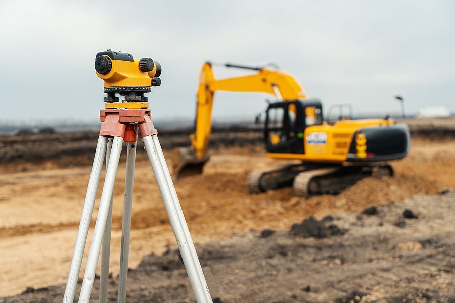
Geo Precision Land Surveying is dedicated to providing accurate, reliable, and comprehensive land surveying services tailored to meet the diverse needs of our clients. With an experienced team of highly skilled professionals and the latest cutting-edge technology, we specialize in a wide range of services, including boundary surveys, topographic mapping, ALTA/NSPS land title surveys, construction staking, flood elevation certifications, and subdivision planning. Our meticulous approach and unwavering commitment to precision ensure that every project—whether large-scale commercial developments or small residential properties—is completed to the highest standards of quality and accuracy. We understand that clear and accurate data is critical for making informed decisions, reducing risks, and achieving successful project outcomes. That’s why we work closely with our clients, providing detailed reports and personalized guidance throughout every stage of the process.
-
![]()
-
![]()
-
![]()
About Us
At Geo Precision, we pride ourselves on delivering exceptional service, fostering long-lasting relationships built on trust, and upholding professionalism in everything we do. With a team of dedicated experts and years of industry experience, we strive to provide accurate, reliable solutions tailored to meet the unique needs of each client in Bronx, NY. Our mission is to empower our clients with the tools, insights, and information they need to move their projects forward with confidence, ensuring success at every stage.
-
![]()


Services
Our land surveying services are meticulously designed to provide accurate, reliable, and comprehensive data to support a wide range of projects across various industries. Utilizing cutting-edge technology, including GPS equipment, drones, and laser scanning, combined with precise techniques, our team delivers detailed surveys that meet and exceed industry standards and regulations. Whether you need boundary determination to resolve property lines, topographic mapping to understand the contours and features of your land, or construction staking to guide your development projects, we ensure accuracy, efficiency, and attention to detail in every step of the process. Additionally, our experienced surveyors work closely with clients to address specific project requirements, ensuring tailored solutions that meet your unique needs. Our ultimate goal is to equip you with the critical insights and data required to make informed decisions, mitigate risks, and achieve successful project outcomes that save time and resources.
Elevation Certificates
Elevation certificates are critical documents that provide essential information about a property’s elevation relative to the base flood elevation. These certificates are often required for floodplain management and to determine accurate insurance premiums for properties in designated flood zones. By obtaining an elevation certificate, property owners can ensure compliance with local regulations, better assess their flood risk, and potentially save on insurance costs. Our team specializes in preparing precise and reliable elevation certificates, leveraging our expertise to deliver accurate results tailored to your needs.
Property, Boundary & Title Surveys
Property, boundary, and title surveys are essential for defining the legal boundaries of a property and resolving potential disputes. These surveys provide a clear and detailed map of the property, showing its dimensions, boundary lines, and any existing structures or improvements. They are often required during real estate transactions, construction projects, or when applying for permits to ensure compliance with zoning and building regulations. Our experienced team utilizes advanced surveying technology and methods to deliver precise and comprehensive results, ensuring you have the accurate information regarding your property for all decision-making.
ALTA | NSPS | ACSM Land Title Survey
An ALTA/NSPS land title survey is a detailed and standardized type of survey specifically designed to meet the requirements of title insurance companies, lenders, and other parties involved in real estate transactions. These surveys provide critical information about property boundaries, easements, encroachments, and improvements, ensuring that all parties have a clear understanding of the property’s condition and any potential risks. By adhering to the stringent standards established by the American Land Title Association (ALTA) and the National Society of Professional Surveyors (NSPS), this type of survey helps mitigate legal disputes and facilitates smoother transactions.
Construction Survey and Stakeout
Construction surveys and stakeout services play a crucial role in bringing design concepts to reality. These surveys ensure that construction projects are accurately aligned with the plans and specifications provided by architects and engineers. By marking the exact locations of structures, utilities, and other site elements, construction stakeouts minimize errors and delays during the building process. Surveyors utilize advanced tools and technology, such as GPS and robotic total stations, to deliver precise measurements essential for project success. This meticulous attention to detail helps avoid costly mistakes, maintains compliance with local regulations, and supports the efficient progression of the construction process.
Profile Surveys
Profile surveys are an essential component of civil engineering and construction projects, providing detailed information about the vertical alignment of a site. These surveys involve measuring and documenting the elevations along a predetermined line or path, which is crucial for tasks such as road design, pipeline installation, and grading plans. By understanding the variations in elevation, engineers can make informed decisions regarding drainage, slope stability, and overall project feasibility.
Topographic Surveys
Topographic surveys are essential for mapping the contours and features of a given area to create a detailed representation of the terrain. These surveys include not only elevation data but also the location of natural and man-made features such as trees, buildings, roads, and bodies of water. The information gathered during a topographic survey is critical for planning and designing infrastructure projects, as it helps identify potential challenges like uneven terrain, flood-prone areas, or obstructions, and ensures that projects are developed with a comprehensive understanding of the environment.
Get a Free Quote Today!
Contact Us
Contact Us Today
From initial consultations to final project completion, our team is dedicated to providing exceptional support and guidance every step of the way. Whether you're embarking on a large-scale construction project or need assistance with property boundaries, we are here to ensure your goals are met with the highest level of professionalism and expertise. Partner with us to experience seamless service and trusted results. Contact us today for a free consultation to discuss your project needs with our expert surveyors and take the first step towards achieving your goals.

"I had a fantastic experience with Geo Precision Land Surveying! Their team was incredibly professional and provided detailed and accurate survey results for my property. Thanks to their expertise, the construction process went smoothly, avoiding any unforeseen issues. Highly recommended!"

"Geo Precision Land Surveying exceeded my expectations with their top-notch service. They were prompt, thorough, and very knowledgeable. The final report was comprehensive and easy to understand. I’ll definitely be using their services again for future projects!"
